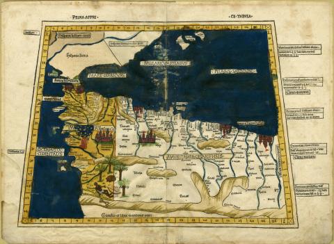
Map of North Africa | Primi Affri
Map of North Africa, Primi Affri
German (Ulm), 1486
Language: Latin
height 41 cm
width 57 cm
From Ulm, Germany. Double-page opening from Ptolemy's Cosmographia, 2nd ed., showing the northwest.
Reed College Library Special Collections, G8220 .P7 1486
Alfred J. Cormack Collection
Kevin Holm, Medieval Portland Capstone Student, Spring 2016
The illustrated map is an extract from the Ancient Greek Astronomer Ptolemy’s Geographia and details the coast of Northern Africa, as well as the lower half of the Iberian Peninsula, including, the Strait of Gibraltar and what appears to be the island of Cadiz. important as the Mediterranean had long been a regional hub of commerce and navigation. Also visible on the map are depictions of various population centers, depicted by the visual shorthand of walled cities and geographic features such as some of the desert regions of the Sahara as well as numerous rivers. There appear to be personal elements added to the map that do not appear in the original publication. These include illustrations of a native among a group of palm trees in the lower left of the map, the coloration of the leftmost portion of the map is not found in other examples of this work, and a heraldic shield on the leftmost portion of the map in what is now Morocco.
There is a high degree of detail in the portion of the map depicting Northern Africa, there is far less in the Iberian Peninsula. This lack of detail in the Iberian Peninsula is an effort to maintain focus on the northern coast of Africa as “Hispania” does indeed receive detailed coverage in a map specific to the region. Many of the maps during this time period feature the north coast of Africa as a strangely squared point of land which may be a distortion from mapping recorded coordinates by relating their position to the city of Alexandria.[7] This map appears to have been undergoing modification by a previous owner as several islands, specifically Cadiz and Formentera along with the Gibraltar peninsula, were recolored green. It is unknown if the recoloring was for a specific purpose or was merely interrupted resulting in its incomplete state. The text included in the map appears to be Latin. This printing, as well as most of those printed in Europe, utilizes an Indo-Arabic numeric system to organize the grid system located around the outer edge of the map. As far as the overall condition of the piece is concerned, there is some wear near the center of the piece near the binding and some staining around the edges of the paper. These imperfections aside, the piece is in remarkably good condition considering its age.
This map is a beautiful example of printed works of the period. Ptolemy's Cosmographia is a compilation of the geographic knowledge of the Roman Empire.[2] At the time of translation in the 13th century, many of the maps were reconstructed from surviving accounts, and coordinates listed in the original maps did not survive with the texts.[6] This edition was published in Ulm, Germany, which is notable because all previous European versions were published in the Italian merchant republics.
This map was, most likely, originally a component of a published book by Johann Reger, a printer from Ulm.[3] This is almost certainly the case because the printer of the first Ulm edition in 1482, Leinhart-Holle, went bankrupt in 1484[3] and this piece is dated as being produced in 1486. It is possible, however, that this is an excerpt from the first edition as Reger utilized the same font and woodblocks used by Leinhart-Holle. This was because they were acquired by the Venetian bookseller and businessman, Justus de Albano, who later commissioned the 1486 second edition[3]. Unlike Leinhart's first edition of this work, Johann's later printing does not receive attention commensurate to its commercial success.[3] Johann incorporated several updated maps into the second edition of the Cosmographia along with two supplementary texts, the Registrum Alphabeticum and the De Locis Ac Mirabilibus Mundi.
Notes:
[1] "Marinus of Tyre"
[2] "At Alexandria Ptolemy Writes the Almagest, the Cosmographia, and the Tetrabiblios"
[3] "The Medieval Texts of the 1486 Ptolemy Edition by Johann Reger of Ulm"
[4] Sotheby's
[5] "The Analysis of Ptolemy's Geography"
[6]"Ptolemy's Geographia"
[7] "Evolution of the Map of Africa"
Bibliography:
Delaney, John. “Evolution of the Map of Africa”, Princeton University Library. Accessed June 2016 http://libweb5.princeton.edu/visual_materials/maps/websites/africa/maps continent/continent.html
Hoogvliet, Margriet. "The Medieval Texts of the 1486 Ptolemy Edition by Johann Reger of Ulm." Taylor & Francis. July 29, 2008. Accessed June 2016. http://www.tandfonline.com/doi/abs/10.1080/03085690208592955.
"Marinus of Tyre." Complete Dictionary of Scientific Biography. 2008. Encyclopedia.com. Accessed May 2016. http://www.encyclopedia.com/doc/1G2-2830905894.html
Norman, Jeremy. "At Alexandria Ptolemy Writes the Almagest, the Cosmographia, and the Tetrabiblos (Circa 100 CE – 178 CE)." : HistoryofInformation.com. Accessed April 2016. http://www.historyofinformation.com/expanded.php?id=186.
Quartich, Bernard. Catalogue of Works on the Fine Arts. London: Publisher not identified 1904. 82.
Quist, Rachel. "Ptolemy's Geographia - Geolounge." Geolounge. November 30, 2011. Accessed May 2016. https://www.geolounge.com/ptolemys-geographia/.
Sayle, E. Charles. Fitzwilliam Museum McClean Bequest. New York: Cambridge University Press, 1916. 40
Sotheby’s. Last Modified April 29, 2014. Last Accessed May, 2016 http://www.sothebys.com/en/auctions/ecatalogue/2014/travel-atlases-maps-natural-history-l14401/lot.114.html
Strang, Alastair. "The Analysis of Ptolemy’s Geography." The Cartographic Journal, 1998th ser., 35, no. 1. Accessed May 2016. http://www.tandfonline.com/doi/pdf/10.1179/000870498787074074.
Wikipedia. "Johann Reger." Last Modified May 16, 2016. Last Accessed June, 2016 https://de.wikipedia.org/wiki/Johann_Reger

